Navigating with a Map and Compass: The Bare Basics
Backcountry PrepBatteries die. Cell phones lose connectivity. Even satellite service can be unpredictable. But a map and compass? You can always count on these two “old schools” tools to discover where you are and how to get to where you’re going.
Truth is, navigating with a tried and true map and compass is an essential outdoor skill. Real explorers don’t ask Apple Maps or Google Maps for directions!
In this post, I bring you up to speed on the basics of using a map and compass in the backcountry. Here’s what you need to know:
Start with a Detailed Topographical Map
The first step is to obtain a map. If all you’re planning to do is hike well-established paths in a park, a basic trail map is all you really need. However, when you’re traveling off-road and off-path, you should have a topographical map. A topographic map shows the physical features of the land, especially its shape and elevation, as shown below.
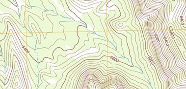
A topographical map is one of the most useful tools for wilderness navigation because it helps you visualize the terrain before you ever set foot on it.
Free Topo Maps: If you’re traveling in the United States, the U.S. Geological Survey offers free topographical maps you can download to print at US Topo. Another option is to purchase a gazetteer (a geographical “directory”) for each state in which you’re planning to travel.
Once you have your map and before you begin your backcountry or wilderness expedition, open it and familiarize yourself with its features: (more…)
TALK TO US
Have any further questions about our courses, what you’ll learn, or what else to expect? Contact us, we’re here to help!