Look Up! Cloud Identification and What the Clouds are Telling Us (Part 3)
June 30, 2020
As we outlined in earlier parts of this series, our instructors are expected to possess a wealth of experiences, as well as areas of knowledge and skills that educate and keep course participants safe, engaged, and active in the backcountry.
An example of that is learning about cloud formations and their relationship to weather. Just like constellations(see: Look Up: A Guide to Viewing the Upper Half of Our Surroundings and bird identification (see: Look Up and Meet Your Feathered Friends), learning the individual names and characteristics of clouds can be a fascinating and worthwhile enterprise, not to mention informative and highly useful from a risk management perspective.
In this, the third and final installment in our “Look Up” series, we cover how to identify the clouds overhead and what those clouds are telling us. Because learning this skill is yet another way our AEE-accredited outdoor education program scaffolds leadership and learning in the backcountry.
Why clouds are important
Clouds, which help regulate temperature and are needed for precipitation, are invaluable in the water cycle. Identifying and them is important in the backcountry, where a sudden weather change can make or break a hike, climb, or whitewater trip. Teaching course participants how to read the clouds builds confidence, which in turn helps participants make informed decisions based on forecasts for what the day, afternoon, or evening ahead may bring.
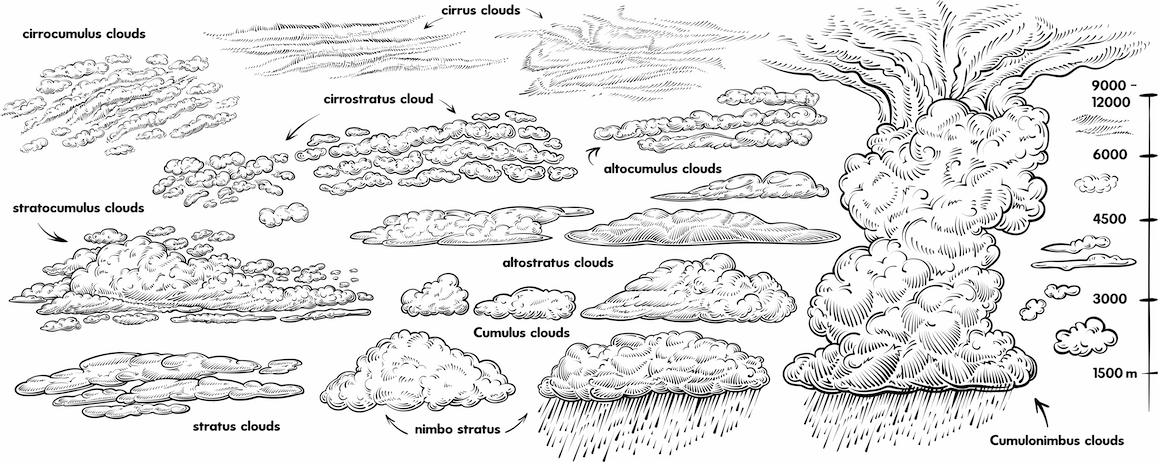
Clouds provide a reliable method of predicting the weather in the backcountry. There are three ways to categorize clouds:
- High-level clouds: Cirrocumulus, Cirrus, and Cirrostratus
- Mid-level clouds: Altocumulus, Altostratus, and Nimbostratus
- Low-level clouds: Stratus, Cumulus, Cumulonimbus, and Stratocumulus
High-level Clouds
Cirrocumulus clouds: These clouds appear like ripples on the water surface, and they portent good weather and the likelihood of coming blue skies.

Cirrus clouds: The most common of the high-altitude clouds, these formations have a wispy look with long streamers as a result of being blown by high winds. Cirrus clouds indicate fair weather and by observing their movement, you can determine the direction from which weather and wind are coming.
Cirrostratus clouds: These are thin, sheet-like clouds that tend to cover the entire sky. They are so translucent that you can easily see the sun and moon through them. And when the sun and moon are visible, you may be able to spot a halo formation in the clouds. The halo is caused by light refracting through ice crystals in the clouds. They indicate a warm front approaching.
Mid-level Clouds
Altocumulus clouds: These clouds look like rounded soft clumps, somewhat similar to a flock of sheep in the sky. These formations are frequently seen after a storm. They may also indicate building cloud cover and afternoon storms.

Altostratus clouds: These appear as grey veils over the sun or moon, and if they become darker and thicker, it is likely rain is on the way.

Nimbostratus clouds: These are the low, dark clouds that blanket the sky, leaving little doubt that precipitation is en route and that it may last for hours.
Low-level Clouds
Stratus clouds: Hung low in the sky, status clouds look like enormous grey blankets. If they extend to the ground, they often become fog. These ominous clouds bring rain, and when it’s cold enough they will produce snow.
Cumulus clouds: Among the most beautiful of the cloud formations, the cumulus clouds look like puffy cotton. In addition to their cheerful appearance, they also indicate fair weather. That is, unless they become cumulonimbus clouds, as you’ll see below.
Cumulonimbus clouds: These are tall clouds, dark on the bottom and sometimes featuring a flat “anvil” top. These clouds indicate severe weather on the way, with thunderstorms, torrential rains, possible hail, snow, and even tornadoes.

Stratocumulus clouds: These dark and lumpy clouds show up just in front of, or immediately behind a frontal system. They may provide a brief period of rain or drizzle that most likely will end during the afternoon or early evening.
Here at The National Center for Outdoor & Adventure Education, our backcountry guides and educators travel the globe on an annual basis, which means we have experienced every form of weather imaginable throughout the year. It is crucial that our instructors understand the indicators that inform of oncoming weather. Knowing how to “read the sky” is a must for all outdoor educators, and it is a skill we love to pass on to our course participants.
TALK TO US
Have any further questions about our courses, what you’ll learn, or what else to expect? Contact us, we’re here to help!
Leave a comment